Hiking at the highest level Schladminger Tauern High Trail


One of the most beautiful multi-day tours in Austria
With five stages through alpine landscapes
The Schladminger Tauern High Trail is a classic among alpine multi-day tours. In five stages over around 45 kilometers or in 7 stages over around 80 km, the route takes you through the water-rich mountain world of the Schladminger Tauern. Crystal-clear mountain lakes, panoramic ridges and rustic huts that invite you to linger await you. Awarded the Austrian Hiking Seal of Quality, the high trail is one of the most beautiful long-distance hikes in the Alps.
The highlights:
- Five stages of around 45 kilometers or seven stages of around 75 kilometers in length
- Overnight stays in rustic huts along the way
- Numerous mountain lakes and waterfalls along the way
- Awarded the Austrian Hiking Seal of Quality
- Demanding alpine route for experienced mountain hikers

Duration: 6-7 hours | Distance: approx. 13 km | Altitude difference: ↑ 820 m, ↓ 725 m
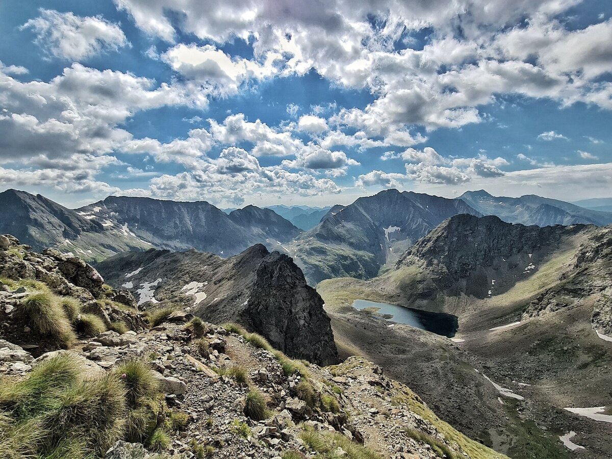
From the Hochwurzenhütte, which you can easily reach with the summit lift, you set off on the panoramic high-altitude trail towards the Giglachseen lakes. You reach the Guschen summit via the Rossfeld and continue over the Schneider summit to the striking elevation of the Schiedeck. Along the way, you will be accompanied by Swiss stone pine forests, small lakes and impressive rock formations. The descent leads down via serpentines to the Ignaz-Mattis-Hütte and Giglachseehütte huts directly on the shores of the Giglachseen lakes.
Duration: approx. 4 hours | Distance: approx. 6 km | Altitude difference: ↑ 584 m, ↓ 638 m
The second stage initially leads along the eastern end of the Giglachseen lakes before the trail climbs over the Knappenkar up to the Rotmandlspitze (2,453 m). From there you can enjoy impressive views over the Schladminger Tauern. You descend via the Kruckeckscharte in large serpentines and reach the Keinprechthütte, idyllically situated at 1,872 m above sea level.
Duration: 6-9 hours | Distance: approx. 9 km | Altitude difference: ↑ 993 m, ↓ 1,200 m
The longest stage starts at the Keinprechthütte and leads over the Trockenbrotscharte into high alpine landscapes. Via the Göriachwinkel up to the Gollingscharte (2,326 m), where a spectacular view of the Hochgolling opens up. From here, you have the option of climbing to the summit of the Hochgolling (2,863 m) before descending over scree and snow fields into the valley to the Gollinghütte.
Duration: 6-8 hours | Distance: approx. 8 km | Altitude difference: ↑ 1,032 m, ↓ 1,024 m
The ascent to the Greifenberg (2,618 m) begins directly behind the Gollinghütte. From the summit, there is a magnificent view of the Klafferkessel - a high mountain cirque with over 30 small lakes. The route continues through this unique landscape via the Klafferscharte before descending via the Lämmerkar to the Preintalerhütte and Waldhornalm.
Duration: approx. 6 hours | Distance: approx. 10 km | Altitude difference: ↑ 741 m, ↓ 1,263 m
From the Preintalerhütte, you hike via the Höfertsteig to the Neualmscharte. The view of the three lakes of the Seewigtal valley is a highlight of this stage. On the descent, you first reach the Obersee, then the Hüttensee and finally the Hans-Wödl-Hütte, which invites you to take a break. Finally, you continue downhill to the Steirischer Bodensee, one of the most famous excursion destinations in the region.

Duration: 6-7 hours | Distance: approx. 13 km | Altitude difference: ↑ 820 m, ↓ 725 m
From the Hochwurzenhütte, the trail leads over the Rossfeld and the Guschen to the Schiedeck. Along the way, you are accompanied by impressive panoramic views and small lakes. The descent leads you in serpentines to the Giglachseen lakes with the Ignaz-Mattis-Hütte and Giglachseehütte.
Duration: approx. 4 hours | Distance: approx. 6 km | Altitude difference: ↑ 584 m, ↓ 638 m
From the Giglachseen lakes, you climb via the Knappenkar up to the Rotmandlspitze (2,453 m) and on to the Kruckeckscharte. You reach the Keinprechthütte via serpentines. Alternatively, a route leads via the Duisitzkarsee lake to the hut.
Duration: 6-9 hours | Distance: approx. 10 km | Altitude difference: ↑ 993 m, ↓ 1,200 m
You ascend to the Gollingscharte (2,326 m) via the Trockenbrotscharte and the Göriachwinkel. Here you have a view of the Hochgolling, which you can optionally climb. The descent leads over scree and snow fields to the Gollinghütte.
Duration: 6-8 hours | Distance: approx. 8 km | Altitude difference: ↑ 1,032 m, ↓ 1,024 m
From the Gollinghütte you climb up to the Greifenberg (2,618 m). From the summit, you can enjoy the most beautiful view of the Klafferkessel with its more than 30 lakes. The descent leads over the Klafferscharte into the Lämmerkar and on to the Preintalerhütte.
Duration: 6-8 hours | Distance: approx. 17 km | Altitude difference: ↑ 1,141 m, ↓ 1,446 m
After the ascent through the Trattenkar cirque, you reach the Trattenscharte (2,408 m), the highest point of the tour. Continue across lakes and alpine pastures to the Lassacheralm and finally to either the Breitlahnhütte or the Putzentalalm at the Schwarzensee.
Duration: 6-8 hours | Distance: approx. 18 km | Altitude difference: ↑ 1,634 m, ↓ 1,042 m
From the Grafenbergalm, you hike via the Rantentörl (2,166 m) and Hubenbauertörl towards the Rudolf Schober Hut. Optionally, you can climb the Predigtstuhl (2,543 m). At the end, you will reach the hut after a varied up and down.
Duration: 5-8 hours | Distance: approx. 12 km | Altitude difference: ↑ 666 m, ↓ 1,198 m
Via the Schimpelscharte, you hike past the Schimpelsee lake and on via the Breitenbachsee lake to the Hohensee lake. You finally reach St. Nikolai im Sölktal along the Bräualmbach water trail. Optional summit: Süßleiteck (2,507 m).
Schladminger Tauern High Trail Package
Your all-round package for your mountain adventure
Our high-altitude trail package makes your multi-day tour particularly uncomplicated. Overnight stays in selected huts, reservations and all important information are already organized. So you can concentrate fully on the experience and enjoy the unforgettable mountain world of the Schladminger Tauern.

Questions and answers
Schladminger Tauern High Trail
Yes, most of the mountain huts on the Schladminger Tauern High Trail have a power connection.
Depending on the location and facilities, however, electricity may be limited at times - especially in huts with solar power or generators.
It is therefore always advisable to take a flashlight or power bank with you.
Yes, there are washrooms with hot showers at several huts along the high-altitude trail.
However, hot water is usually only available for an extra charge and at certain times.
As water is scarce at an altitude of over 2,000 m, you should use it sparingly.
If you have to break off the stage plan or descend into the valley earlier, please inform the hut you have booked immediately that you will not be arriving.
This is important so that no search operation is triggered.
In the event of injuries or emergencies, call the Alpine emergency number 140 and, if possible, stay in a safe place.
Charging cell phones, watches or GPS devices is possible in many huts for a small fee.
As the power supply in the mountains is limited, sockets are usually only provided in the common rooms.
A power bank is ideal to ensure you have enough energy for the entire hut tour in the Schladminger Tauern.
Cell phone reception in the Schladminger Tauern is very limited.
In some valleys or altitudes there is no network reception, especially between the mountain huts.
Important emergency numbers (e.g. Alpine emergency number 140) should be stored in your cell phone before you set off.
Due to the altitude and limited supply, vegan or gluten-free meals can only be offered to a limited extent.
Some huts make an effort to accommodate special dietary requirements if these are announced in advance.
Hikers with special dietary requirements are advised to bring their own products or snacks.
The mountain boot is an essential criterion for how we remember a mountain experience. The most impressive mountain panorama can open up in front of you and the hut owner can serve you the best snack for refreshment, but if your boots literally pinch and painful blisters form, it is difficult to enjoy the mountain experience. Here are three tips to help you choose the right footwear:
- Get used to the footwear: Every shoe has its own characteristics. Break in new mountain boots first on short walks or short tours so that your foot adapts and you avoid pressure points.
- Consider the nature of the trail: Make sure that your shoe is suitable for the tour. Models with a high shaft and firm sole are ideal for stony or alpine terrain, while lighter low shoes are better suited to easy hiking trails.
- Consider the overall situation: Whether it's a heavy rucksack, a long route or uneven terrain: all of these factors influence how much stability and protection you need. Lightweight low shoes are comfortable, but can quickly become a tripping hazard when combined with a lot of luggage or rough terrain.
You should prepare well for a successful mountain experience:
- Fit for the hike: Strengthen your muscles and coordination with simple exercises such as squats, lunges and balancing. This will give you more stamina and confidence on your hike.
- Choose your equipment wisely: In addition to basics such as water, shoes and weatherproof clothing, a camera and power bank are valuable companions. The onion look ensures that you remain flexible when the weather changes.
- Set realistic goals: Plan your tours so that they suit your fitness level and increase step by step. Also make a note of important emergency numbers (140 - Alpine emergency number, 112 - Euro emergency number) so that you can act quickly in an emergency.