contact
contact
ForYou Club
1 / 76 lifts
0 / 152 slopes
2 / 39 XC-Trails
2 °C
Webcam
Current info
back
Grimming-Donnersbachtal

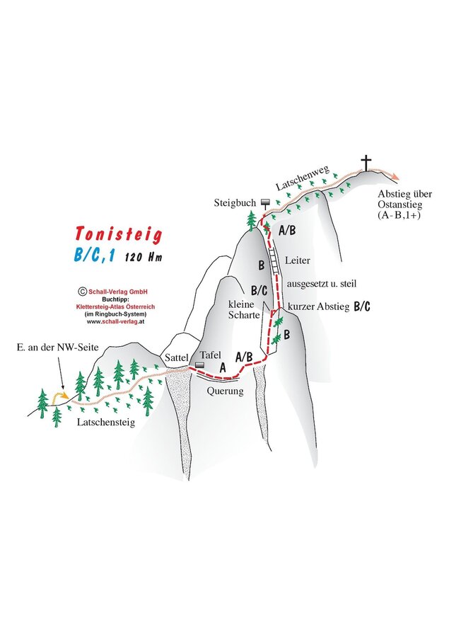
Via Ferrata Tonisteig

Tour description

The Tonisteig is a well-secured, occasionally very exposed via ferrata leading to a striking summit. The descent via the east side is rather loose and slippery in parts and less beautiful. However, in combination with the Tonisteig, it is a highly recommended way to cross the Hochtausing. Also possible in the reverse direction, of course.

Remark:

The approach to the Tonisteig leads a little longer via the Schneehitzalm due to the hunting ban on the Tausingkar.

Times:

  • Via Ferrata - 0:30 h
  • Time to Base - 2:00 h
  • Time from Top - 1:30 h
  • Total - 4:00 h

The tour

moderate
Starting and end point Wörschach
Tour characteristics
Fitness (3/6)
Information
Distance: 9.42 km
Duration: 4 h
Ascent: 727 m
Descent: 727 m
highest point: 1823 m
Best season
Jan
Feb
Mar
Apr
May
Jun
Jul
Aug
Sep
Oct
Nov
Dec

Map, elevation profile & further information

Approach:

From the car park along the marked path in the direction of the Hochmölbinghütte as far as the Langpoltner Klamml. Here, make a left towards the Schneehitzalm, then head southeast on the cart path in the direction of the Hochtausing

Descent:

The eastern approach is marked in red, secured in parts, with some scrambling required (rated up to 1+). After reaching the path up, another 30 – 40 min until you reach the start of the actual via ferrata.

Leave the Ennstal federal road (B320) in Wörschach. In the village, turn off in the direction of Wörschachberg, drive up to the Oberkogler-Alm and continue to Schönmoos.Schönmoos car park - On busy days, the car park can fill up very early. Then you have to park before the Oberkogler Alm.

Parkplatz Schönmoos

Parkplatz Oberkogler Alm

Onward journey possible by taxi.

Ennstal Taxi: +43 660 6633666

Klettersteigen ist ein anspruchsvoller Sport inmitten herrlicher, rauer Natur. Bitte beachte einige Regeln zu Deiner Sicherheit:

  • Klettersteig-Touren sind kraftraubend und erfordern Kondition, Schwindelfreiheit und Trittsicherheit.
  • Unbedingt immer ein Klettersteigset/Klettersteigausrüstung und einen Helm verwenden und im Sicherungsseil einhängen. Viele Bergrettungseinsätze sind auf Leichtsinn und schlechtes Wetter zurückzuführen.
  • Stets rücksichtsvoll verhalten. Andere Klettersteiger respektieren und über Gefahren informieren. Sorgsam mit der Natur umgehen!

Tour auf eigene Gefahr! Es wird keinerlei Haftung bzgl. allfällig gegebener bzw. auftretender Alpingefahren (Wetter, etc..) übernommen. 

Bergrettung 140

Europa Notruf 112

Komplettes Klettersteigset und Helm.

Take a lot of to drink with you.Sommerfreizeitkarte WEST - available in all information offices of the TV Schladming-Dachstein

Alpenvereinskarte Nr. 14 - Dachsteingebirge

KOMPASS Karte 031 Der Dachstein, Ramsau, Filzmoos - available in the information office Ramsau am Dachstein

Klettersteige (Via Ferratas) - Atlas Österreich Schall Verlag - only in German

Via Ferratas English- TV Schladming-Dachstein (You will find the pdf file under "Klettersteige")

Wheather predicition

today
07.11.2025
Mountain 8 °C
Valley 10 °C
Precipitation
Probability
0 %
Amount
0 l/m²
Wind speed
Sued
20 km / h
Sun
Sun hours
9.7 h
Sunrise
06:57 o clock
Sunset
16:37 o clock

Dry and sunny throughout the day with hardly any clouds.

tomorrow
08.11.2025
Mountain 4 °C
Valley 8 °C
Precipitation
Probability
5 %
Amount
0 l/m²
Wind speed
Nordwest
10 km / h
Sun
Sun hours
7.9 h
Sunrise
06:58 o clock
Sunset
16:36 o clock

Dry and bright with plenty of sunshine, clouds will be rare.

day after tomorrow
09.11.2025
Mountain 2 °C
Valley 9 °C
Precipitation
Probability
40 %
Amount
0.2 l/m²
Wind speed
Nordwest
10 km / h
Sun
Sun hours
0.6 h
Sunrise
07:00 o clock
Sunset
16:34 o clock

Mostly cloudy through the day with a chance of occasional sunny spells.

Tours nearby