Via Ferrata Koppenkarstein Westgrat

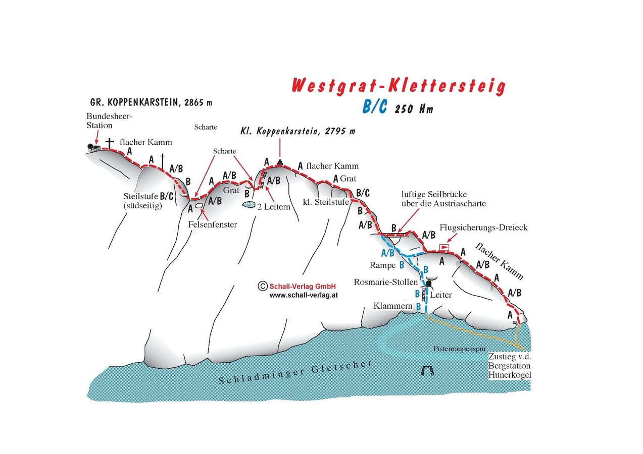
Tour description
Times:
- Via Ferrata - 1:30 h
- Time to Base - 0:15 h
- Time from Top - 1:50 h
- Total - 3:30 h
The tour
Map, elevation profile & further information
Descent: go back via the rope bridge to the Rosmarie-Stollen and via the ladder down to the glacier, or follow the same path you used for the ascent.
Arriving from the west:
From the west you can take the Munich-Salzburg motorway, continuing on the Tauern motorway (A 10) until the Ennstal junction. From here take the Ennstal A-road (the B 320) for around 30 km into the Schladming-Dachstein region, then take the Ramsau am Dachstein turn-off. Drive through the Ramsau Village and then turn left to Dachstein toll road. Continue up to the parking place Türlwand Hütte.
Arriving from the north:
From the south-east take the Pyhrnautobahn motorway (A 9) to the Liezen junction and then the Ennstal A-road (B 320) into the Schladming-Dachstein region. Then take the Ramsau am Dachstein turn-off. Drive through the Ramsau Village and then turn left to Dachstein toll road. Continue up to the parking place Türlwand Hütte.
Hiking Via Ferrata routes is a demanding sport in rugged terrain. For your safety, please observe the following rules:
- Via Ferrata routes are demanding and require a good level of fitness, no hight vertigo and sure-footedness.
- Always use a helmet and, a Via Ferrata kit to attach yourself to the safety rope. Many mountain rescue missions are a result of carelessness and bad weather conditions.
- Many routes require most of the day. When planning a tour, always include the possibility of a sudden change of weather. Be prepared: carry spare clothing and a good stock of food supplies.
- Always show respect towards fellow mountaineers. Inform them about possible dangers if need be.
- Take care of our environment. Only take photographs and memories with you - leave no trace.
Alpine Emergency Numbers
Mountain Rescue 140
Euro Emergency Call 112
Via Ferrata Equipment
Up-to-date information: Bergführerbüro Ramsau am Dachstein or phone +43 664 522 0080.
Sommerfreizeitkarte WEST - available in all information offices of the TV Schladming-Dachstein
Alpenvereinskarte Nr. 14 - Dachsteingebirge
KOMPASS Karte 031 Der Dachstein, Ramsau, Filzmoos - available in Information office Ramsau am Dachstein
Klettersteige (Via Ferratas) - Atlas Österreich Schall Verlag - only in German
Via Ferratas English- TV Schladming-Dachstein (You will find the pdf file under "Klettersteige")


